The cold front held Miami to 71 degrees on Saturday, Nov. 14, 10 below normal. The low was 61 at 7:24 a.m. Sunday, not the 58 forecast.
Updated Nov. 18: the National Weather Service’s climate reports for Miami International Airport show the front’s real effect. Saturday, Nov. 14, peaked at 71 degrees, 10 below normal, with a low of 64. Sunday morning was the coldest, at 61 degrees at 7:24 a.m., seven below normal. The forecast low of 58 was not reached at the airport. Sources: the daily climate reports for Nov. 14 and Nov. 15.
The coolest air of the season so far is on its way to Miami. A strong cold front is forecast to cross South Florida Thursday night into Friday, and overnight lows in the city could fall to the upper 50s. Forecasters said South Florida last saw lows below 60 degrees in March.
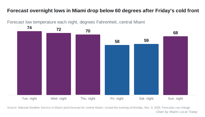
The National Weather Service in Miami expects a low near 58 degrees Friday night in central Miami. Saturday should be sunny with a high near 72. The forecast is in the point forecast for central Miami issued Monday evening.
What the forecast says, day by day
The weather service’s forecast for central Miami, issued Monday evening:
| Day | High | Night low | Rain chance and notes |
|---|---|---|---|
| Tuesday | 84 | 74 | Mostly sunny |
| Wednesday, Nov. 11 (Veterans Day) | 84 | 72 | 30% chance of showers and storms, mainly after 1 p.m. |
| Thursday | 84 | 70 | 20% chance of storms after 1 p.m.; the front arrives overnight |
| Friday | 77 | 58 | Slight chance of showers 7 a.m. to 1 p.m.; northwest wind, gusts to 18 mph at night |
| Saturday | 72 | 59 | Sunny |
| Sunday | 76 | 68 | Sunny |
Monday, Nov. 16, warms back to a high near 79.
Why it will feel so different
Forecasters said the air behind the front comes from the Arctic, though it will warm up a good deal on the way south. In its forecast discussion Monday, the Miami office said:
- temperatures this weekend are forecast to run roughly 10 to 15 degrees below average for this time of year
- morning lows Saturday and Sunday are forecast in the upper 50s along the east coast and the low 50s on the southwest coast
- the last time South Florida saw lows below 60 degrees was mid to late March
The office also said the exact numbers may still shift over the next several days.
Storms before the front
The timing of the front will decide Friday’s weather. Forecasters said a faster front would limit showers and storms as it crosses overnight. A slower one would leave more time for daytime heating on Friday, and a better chance of storms.
Wednesday afternoon also carries a chance of storms. The weather service said any strong storm could bring heavy downpours, frequent lightning and gusty winds, though the chance of strong storms is low.
What it means for you
- Friday night and Saturday morning: plan for the upper 50s. A jacket is worth having for early walks, and the weekend should be dry.
- Outdoor plans this weekend: Saturday and Sunday are forecast sunny, with highs of 72 and 76. Our things to do this weekend guide lists what is on.
- Veterans Day: the rain chance Wednesday is mainly after 1 p.m., so morning events look drier. Our Veterans Day page has parade and ceremony times.
- On the water: northwest winds pick up behind the front Friday, with gusts to 18 mph Friday night in the city forecast. Check the weather service’s marine forecast before heading onto Biscayne Bay.
- Check again Thursday. This is a forecast several days out. We will update this story when the front has passed.
Have your say